“Monitoring the status of our freshwater lakes and rivers has never been more important. Regular observation is essential to determine their health, quickly identify trends and acknowledge signs of degradation particularly for areas in scarce supply.”
The 1968 Earthrise photograph, a photograph of the Earth and parts of the Moon‘s surface taken by astronaut Bill Anders in 1968 during the Apollo 8 mission, shows the beauty and fragility of the Earth, and helped spark a worldwide environmental movement. Now the comprehensive coverage of the earth provided by satellites helps us understand global change and the need to optimize and adapt environmental decision-making.
Earth Observation (EO) is not new, but it is only recently that investments in satellite capabilities and advances in algorithms and data processing have started to enable the widespread use of this intelligence information at scale.
In the last decade satellite data have become available in increasing quantities and at very low to no cost. This makes Earth Observation applications more attractive in addressing societal challenges.
Earth Observation provides factual information and quantitative data cost-effectively and quicker than conventional methods, delivering wide-area surveillance as well as pin-pointing targeted locations for monitoring specific operations in response to intelligence requirements.
Monitoring water quality through remote sensing
Water quality is one of biggest challenges facing our civilization today – reduced water quality threatens human health, limits food production, and hinders economic growth. Newly emerging pollutants and changing climate patterns bring about new water quality challenges.
Monitoring water quality is an important part of environmental monitoring and can help researchers predict and understand natural processes in the environment and determine human impacts on an ecosystem. When water quality is poor, it affects not only aquatic life but also the surrounding ecosystem. These measurement efforts can assist in restoration projects or ensure environmental standards are being met.
Parameters that affect the water quality in the environment can be physical, chemical or biological and are relevant not only to surface water studies of the ocean, lakes and rivers, but to groundwater and industrial processes as well.
Localized information, for e.g. on sediments in the water column, harmful algae blooms, eutrophication and geophysical parameters such as temperature or ice coverage, and their temporal and spatial patterns, are an obligatory aspect of most water related applications. These include planning and evaluation of dams and river management using sediment measurements; environmental impact and water directive monitoring of various quality indicators in lakes for environmental agencies; monitoring harmful cyanobacteria blooms in bathing lakes for district offices and organic loads and turbidity in water reservoirs for utilities. Water quality measures are increasingly used by ministries and intergovernmental entities as proxies for the Sustainable Development Goals (SDG) defined by the UN, or to evaluate the impact of climate change.
So what is the added value of Earth Observation in monitoring and reporting water quality indicators?
The increasing demand for continuous information over millions of water bodies and thousands of user organizations cannot be met using only traditional approaches, which involve significant limitations. Manual sampling, with laboratory analysis only, or in-situ probes are logistically limited and cost-extensive. Agencies responsible for hundreds or thousands of lakes only have capacities to collect data for a handful of lakes with few measurements per year – and this is the case in highly developed countries. In view of large natural spatial and temporal variability, where one parameter can change by a magnitude within two observations, there is a huge demand: Closing information gaps with capable and cost-efficient new approaches.
“Monitoring the status of our freshwater lakes and rivers has never been more important. Regular observation is essential to determine their health, quickly identify trends and acknowledge signs of degradation particularly for areas in scarce supply,” says Dr. Thomas Heege, CEO, EOMAP GmbH & Co. KG.
“Regular monitoring not only helps to identify problems quickly, but determines whether pollution control programmes are working and helps to direct efforts to where they are most needed. “
Earth observations, which include both satellite and in-situ data, can provide robust monitoring for water quality indicators because of their geospatial consistency, accessibility, repeatability, and global coverage. An overview of the capabilities of remote sensing for lake monitoring is given in Dörnhöfer & Oppelt 2016, covering the appropriate satellite sensors and possible parameters, which can be derived using satellite processing technologies.
Water quality services based on Earth Observation data providing comparable assessments on transnational scale can be used as a complement to national assessments of several water monitoring related directives in Europe, including the Water Framework Directive (WFD), Marine Strategy Framework Directive (MSFD), Nitrates Directive (ND) or Floods Directive (FD).
In order to fulfill the requirements of the water monitoring directive and monitoring obligations of the water authorities, Earth Observation provides access to a wide range of water monitoring parameters from different satellite data sources. The resolution requirements are supported through the various optical satellite sensors, such as Copernicus missions of Sentinel 2 and 3 with 10 and 300 m, Landsat 7/8 for weekly measurements in 30m or Worldview-2/3 or Pleiades in 2 m resolution, as commercial high-resolution satellites daily observations on request. The very high resolution data are used for a more detailed analysis of ice phenomena, hydromorphology and macrophytes.
Examples of EO based water quality parameters, application fields and satellite sources are given in Table 1 below:
| Parameter | Purpose | Resolution spatial/temporal | |
| 1 | Turbidity | WFD, ecosystem monitoring | Sentinel-2: 10m/5-10 days
Landsat 7/8: 30m/8 days Sentinel 3: 300m/1-2 days |
| 2 | Chlorophyll-a | WFD, MSFD, ND, HELCOM, ecosystem monitoring | Sentinel-2: 10m/5-10 days
Landsat 7/8: 30m/8 days Sentinel 3: 300m/1-2 days |
| 3 | Temperature | WFD, ecosystem monitoring | Landsat 7/8: 100m
Sentinel 3: 1000m/1-2 days |
| 4 | Colored Dissolved Organic Matter | WFD, ecosystem monitoring | Sentinel-2: 10m/5-10 days
Landsat 7/8: 30m/8 days Sentinel 3: 300m/1-2 days |
| 5 | Harmful Algae Blooms | WFD, ND, ecosystem monitoring, health protection, Bathing Water Directive (2006/7/EC) | Sentinel-2: 10m/5-10 days
Landsat 7/8: 30m/8 days Sentinel 3: 300m/1-2 days |
| 6 | Macrophytes | WFD, ecosystem monitoring | WorldView: 2m/on demand
Sentinel 2: 10m/5-10-days |
| 7 | Ice coverage | FD, State of freezing/thawing, planning of in situ maesurements | Pleiades: 2m/on demand
WorldView: 2m/on demand Sentinel-2: 10m Landsat 7/8: 30m Sentinel 3: 300m/1-2 days |
| 8 | Water extent | WFD, FD | Sentinel-2: 10m/5-10 days
Landsat 7/8: 30m/8 days Sentinel 3: 300m/1- days Sentinel-2: 10m/5-10 days Landsat 7/8: 30m/8 days Sentinel 3: 300m/1-2 days Sentinel 1:20m/2 days |
| 9 | Transparency | WFD | Sentinel-2: 10m/5-10 days
Landsat 7/8: 30m/8 days Sentinel 3: 300m/1-2 days |
| 10 | Hydro-morphological changes | WFD, FD | Sentinel-2: 10m/5-10 days
Landsat 7/8: 30m/8 days Sentinel 3: 300m/1-2 days |
| 11 | Riverine impact areas | Impact areas of the riverine waters from the drainage basin to the estuaries | Sentinel-2: 10m/5-10 days
Landsat 7/8: 30m/8 days Sentinel 3: 300m/1-2 days |
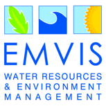
Within SPACE-O, EOMAP GmbH & Co. KG is responsible for the operational processing of Earth Observation data for two reservoirs, Aposelemis on Crete and Mulargia in Italy, using its proprietary, physics-based Modular Inversion and Processing System (MIP) (Heege et al. 2014). A comprehensive range of satellite-based water quality parameters such as turbidity, chlorophyll-a and indicators for toxic cyanobacteria blooms are monitored with weekly or almost daily sampling frequencies under cloud-free conditions. Historic measurements are also provided throughout 2013 to 2016, and are continued for 2017 on a daily basis.
In view of existing data gaps due to unfavourable weather conditions (clouds, haze, sunglint), there are already new approaches developed to mitigate these data gaps.
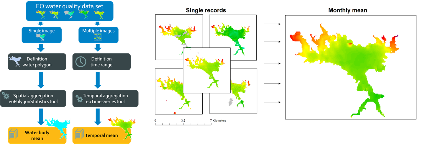
“The Earth Observation based water quality data generated within the SPACE-O project are aggregated into spatial and temporal means and allow accurate and timely reporting,” explains Karin Schenk, project manager for Space-O at EOMAP GmbH & Co. KG.
SPACE-O – EU Horizon 2020 funded project – has recognized the growing need to monitor the effects of pollution on our global water cycle. The interdisciplinary project integrates state-of-the-art satellite technology and in-situ monitoring with advanced hydrological water quality models and ICT tools, into a powerful decision support system.
References:
Dörnhöfer, K., Oppelt, N. (2016): Remote sensing for lake research and monitoring – Recent advances. Ecological Indicators, 64, 105-122.
Heege, T., Kiselev, V., Wettle, M., Hung N.N. (2014). Operational multi-sensor monitoring of turbidity for the entire Mekong Delta. Int. J. Remote Sensing, Special Issues Remote Sensing of the Mekong, Vol. 35 (8), pp. 2910-2926.
The blog was written by EOMAP GmbH & Co. KG, a SPACE-O Project consortium partner.
If you are interested in joining the discussion on the use of Earth Observation for Improved Water Management, visit our discussion group dedicated to the topic at the International Water Association’s IWA Connect. If you are not yet a member of IWA Connect, you can easily join as a network member for free here. Once you are logged-in, you can access the discussion group here.